
Average Ratings 0 Ratings
Average Ratings 0 Ratings
Similar Products
-
IntelexIntelex delivers a unified software system for overseeing Environmental, Health, Safety, and Quality (EHSQ) initiatives. Its expandable platform is crafted to consolidate, oversee, and scrutinize EHS and Quality data comprehensively. The solution works on any device to meet the realities of your workplace. With Intelex, your organization can: Elevate your EHSQ program outcomes by supervising workflows for superior performance and command. Discern patterns and propensities through goal-setting to deepen understanding and improve decision-making in your EHSQ program. Diminish occurrences and cut down on administrative tasks by efficiently supervising, managing, refining, and extracting insights from your safety data via our intuitive safety software. Simplify the management and reporting of air, water, and waste emissions, and oversee environmental outputs to fulfill sustainability objectives. Foster ongoing improvements in quality by seamlessly logging and monitoring all instances of nonconformity within a unified, web-based system. Investigate trends across various departments, sites, or locations. Intelex can help you manage compliance with international standards and regulations such as: OSHA, WCB, ISO 45001, EPA, ISO
-
groundcoverCloud-based solution for observability that helps businesses manage and track workload and performance through a single dashboard. Monitor all the services you run on your cloud without compromising cost, granularity or scale. Groundcover is a cloud-native APM solution that makes observability easy so you can focus on creating world-class products. Groundcover's proprietary sensor unlocks unprecedented granularity for all your applications. This eliminates the need for costly changes in code and development cycles, ensuring monitoring continuity.
-
DataBuckBig Data Quality must always be verified to ensure that data is safe, accurate, and complete. Data is moved through multiple IT platforms or stored in Data Lakes. The Big Data Challenge: Data often loses its trustworthiness because of (i) Undiscovered errors in incoming data (iii). Multiple data sources that get out-of-synchrony over time (iii). Structural changes to data in downstream processes not expected downstream and (iv) multiple IT platforms (Hadoop DW, Cloud). Unexpected errors can occur when data moves between systems, such as from a Data Warehouse to a Hadoop environment, NoSQL database, or the Cloud. Data can change unexpectedly due to poor processes, ad-hoc data policies, poor data storage and control, and lack of control over certain data sources (e.g., external providers). DataBuck is an autonomous, self-learning, Big Data Quality validation tool and Data Matching tool.
-
GrafanaGrafana Labs provides an open and composable observability stack built around Grafana, the leading open source technology for dashboards and visualization. Recognized as a 2025 Gartner® Magic Quadrant™ Leader for Observability Platforms and positioned furthest to the right for Completeness of Vision, Grafana Labs supports over 25M users and 5,000+ customers. Grafana Cloud delivers the full power of Grafana’s open and composable observability stack—without the overhead of managing infrastructure. As a fully managed SaaS offering from Grafana Labs, it unifies metrics, logs, and traces in one place, giving engineering teams real-time visibility into systems and applications. Built around the LGTM Stack—Loki for logs, Grafana for visualization, Tempo for traces, and Mimir for metrics—Grafana Cloud provides a scalable foundation for modern observability. With built-in integrations for Kubernetes, cloud services, CI/CD pipelines, and OpenTelemetry, Grafana Cloud accelerates time to value while reducing operational complexity. Grafana Cloud also supports OLAP-style analytics through integrations with data warehouses and analytical engines like BigQuery, ClickHouse, and Druid—enabling multi-dimensional exploration across observability and business data. Teams gain access to powerful features like Adaptive Metrics for cost optimization, incident response workflows, and synthetic monitoring for performance testing—all within a secure, globally distributed platform. Whether you’re modernizing infrastructure, scaling observability, or driving SLO-based performance, Grafana Cloud delivers the insights you need—fast, flexible, and vendor-neutral.
-
ArboStarARBOSTAR stands at the forefront of business management solutions for the tree care and landscaping industry, offering a revolutionary, all-in-one platform. This cloud-based system is designed for businesses of any size, integrating essential tools to streamline operations. From Client Relationship Management (CRM) and Field & Equipment Management to Business Analytics, Accounting, Finance, Payment Processing, IP Telephony & SMS, Human Capital Management, and Quality Assurance with an ERP system, ARBOSTAR brings every necessary module under one roof for efficient and effective management. The interactive Map View feature further simplifies scheduling and marketing by showing real-time locations of leads, crews, and equipment, optimizing your business operations with ease.
-
KrakenDEngineered for peak performance and efficient resource use, KrakenD can manage a staggering 70k requests per second on just one instance. Its stateless build ensures hassle-free scalability, sidelining complications like database upkeep or node synchronization. In terms of features, KrakenD is a jack-of-all-trades. It accommodates multiple protocols and API standards, offering granular access control, data shaping, and caching capabilities. A standout feature is its Backend For Frontend pattern, which consolidates various API calls into a single response, simplifying client interactions. On the security front, KrakenD is OWASP-compliant and data-agnostic, streamlining regulatory adherence. Operational ease comes via its declarative setup and robust third-party tool integration. With its open-source community edition and transparent pricing model, KrakenD is the go-to API Gateway for organizations that refuse to compromise on performance or scalability.
-
New RelicAround 25 million engineers work across dozens of distinct functions. Engineers are using New Relic as every company is becoming a software company to gather real-time insight and trending data on the performance of their software. This allows them to be more resilient and provide exceptional customer experiences. New Relic is the only platform that offers an all-in one solution. New Relic offers customers a secure cloud for all metrics and events, powerful full-stack analytics tools, and simple, transparent pricing based on usage. New Relic also has curated the largest open source ecosystem in the industry, making it simple for engineers to get started using observability.
-
dbtdbt Labs is redefining how data teams work with SQL. Instead of waiting on complex ETL processes, dbt lets data analysts and data engineers build production-ready transformations directly in the warehouse, using code, version control, and CI/CD. This community-driven approach puts power back in the hands of practitioners while maintaining governance and scalability for enterprise use. With a rapidly growing open-source community and an enterprise-grade cloud platform, dbt is at the heart of the modern data stack. It’s the go-to solution for teams who want faster analytics, higher quality data, and the confidence that comes from transparent, testable transformations.
-
QlooQloo, the "Cultural AI", is capable of decoding and forecasting consumer tastes around the world. Privacy-first API that predicts global consumer preferences, catalogs hundreds of million of cultural entities, and is privacy-first. Our API provides contextualized personalization and insight based on deep understanding of consumer behavior. We have access to more than 575,000,000 people, places, and things. Our technology allows you to see beyond trends and discover the connections that underlie people's tastes in their world. Our vast library includes entities such as brands, music, film and fashion. We also have information about notable people. Results are delivered in milliseconds. They can be weighted with factors like regionalization and real time popularity. Companies who want to use best-in-class data to enhance their customer experiences. Our flagship recommendation API provides results based on demographics and preferences, cultural entities, metadata, geolocational factors, and metadata.
-
NeuBirdNeuBird's premier offering, Hawkeye (Agentic AI SRE), is an innovative Site Reliability Engineering platform powered by artificial intelligence that revolutionizes IT operations through the continuous observation of telemetry derived from your entire observability stack, including logs, metrics, traces, alerts, and incident tickets. It enables the detection of problems, thorough root cause analysis, and offers or automates effective solutions in real-time, eliminating the need for manual investigation. Designed specifically for enterprise-scale environments, Hawkeye delivers secure integration with a variety of existing monitoring and incident management systems, such as DataDog, Splunk, PagerDuty, Prometheus, ServiceNow, AWS CloudWatch, Azure Monitor, and several others. By correlating signals from diverse sources and reasoning in a manner similar to a human engineer, it uncovers actionable insights that can significantly decrease the mean time to resolution (MTTR) by nearly 90%. Operating continuously, Hawkeye can be deployed as a Software as a Service (SaaS) or within a customer's Virtual Private Cloud (VPC), equipped with robust enterprise security measures, and provides features like autonomous incident response and advanced pattern recognition, making it a comprehensive solution for modern IT challenges. Additionally, its ability to adapt and learn from ongoing operations ensures that organizations can maintain high availability and performance levels in a rapidly evolving technological landscape.
Description
Accessing Earth observation data for your application has never been easier. EarthCache™ offers an incredibly powerful and user-friendly API that connects you to satellite data from around the globe. By utilizing a single point of access, you can focus on development rather than data sourcing, retrieving analysis-ready archives and future datasets with resolutions ranging from 50 cm to 30 m. Developers will appreciate the efficiency of EarthCache, which consolidates multiple sources into one cohesive platform. With EarthCache, you gain seamless access to premier Earth observation data alongside sophisticated processing algorithms tailored for application developers. Our service aggregates and standardizes data from top-tier industry partners, saving your team from the lengthy process of integrating various systems. Building your data pipeline has never been simpler; just grab your code and integrate it within minutes. Designed specifically for developers, you can easily programmatically search and request the Earth observation data you require through a straightforward one POST, one GET model. Additionally, you have the capability to schedule pipelines that monitor designated areas of interest, ensuring you remain updated with the latest information.
Description
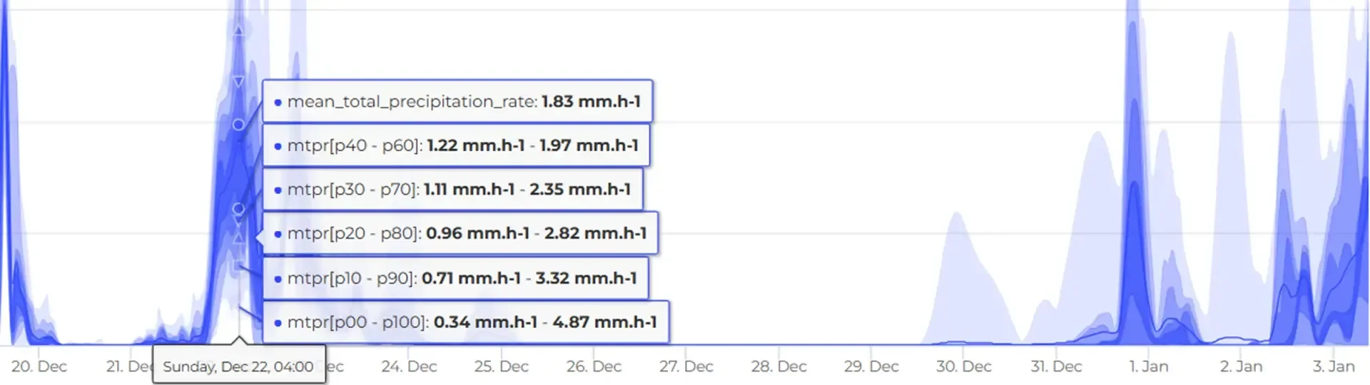
Frogcast is a cutting-edge global weather forecasting API that provides extremely precise and localized weather predictions by integrating over 20 advanced numerical weather prediction models with state-of-the-art artificial intelligence and diverse geospatial data from top-tier organizations such as ECMWF and NOAA, alongside earth observation data and ground-level measurements, to aid crucial decision-making in fields like agriculture, construction, logistics, retail, insurance, environment, transport, and health. Its RESTful API grants access to an impressive array of more than 26 meteorological variables, offering forecasts that extend up to 15 days into the future, along with probabilistic forecasts that include confidence intervals and quantiles for enhanced understanding, all while delivering high spatial resolution down to 1 km and detailed topographic information at 90 m for focused targeting of specific areas. The Frogcast platform is designed for effortless integration into current systems and applications via intuitive API endpoints utilizing standard web protocols and JSON data formats, which facilitates both real-time and historical weather data analysis for trend identification and decision support. Additionally, the flexibility of the API allows for customization based on user needs, enhancing the overall user experience and effectiveness of the weather data provided.
API Access
Has API
API Access
Has API


Pricing Details
No price information available.
Free Trial
Free Version
Pricing Details
€54 per 400 requests per month
Free Trial
Free Version
Deployment
Web-Based
On-Premises
iPhone App
iPad App
Android App
Windows
Mac
Linux
Chromebook
Deployment
Web-Based
On-Premises
iPhone App
iPad App
Android App
Windows
Mac
Linux
Chromebook
Customer Support
Business Hours
Live Rep (24/7)
Online Support
Customer Support
Business Hours
Live Rep (24/7)
Online Support
Types of Training
Training Docs
Webinars
Live Training (Online)
In Person
Types of Training
Training Docs
Webinars
Live Training (Online)
In Person
Vendor Details
Company Name
SkyWatch Space Applications
Founded
2014
Country
Canada
Website
www.skywatch.com
Vendor Details
Company Name
QUOS Group
Founded
2021
Country
France
Website
www.frogcast.com
Product Features
Forestry
Barcoding / RFID
Contract Management
Cost Accounting
Customer Management
Financial Management
Harvest Management
Order Processing
Pricing Management
Production Tracking
Supplier Management
Transportation Management
GIS
3D Imagery
Census Data Integration
Color Coding
Geocoding
Image Exporting
Image Management
Internet Mapping
Interoperability
Labeling
Map Creation
Map Sharing
Near-Matching
Reverse Geocoding
Spatial Analysis
Land Management
Code Enforcement
Document Management
For Oil & Gas
GIS
Inspection Management
Lease Management
Permit Management
Planning & Zoning
Project Management
Mining
3D Modeling
Cross Section Creation
Data Exchange
Data Storage
Exception Notification
Fence Diagrams
Log Map Creation
People Tracking
Pit Optimization Reporting
Risk Management
Volumetrics
Oil and Gas
Compliance Management
Equipment Management
Inventory Management
Job Costing
Logistics Management
Maintenance Management
Material Management
Project Management
Resource Management
Scheduling
Work Order Management
