Average Ratings 0 Ratings
Average Ratings 0 Ratings
Similar Products
-
OmnilertSave lives by detecting potential threats early and responding quickly with visual gun detection. Our AI-powered Gun Detect software provides reliable, 24-hour monitoring of security cameras. This makes it easy to deploy an early gun detection solution. Our Emergency Communications and Automation Platform shares intelligence by automatically activating emergency response plans and safety system. We help you maximize every second and protect your people from danger, no matter what the threat is, from guns to severe storms. Protect your people, facilities, and operations from any threat you face today.
-
SKU ScienceSKU Science delivers a fast and intuitive solution for sales forecasting and performance tracking. Implement your demand planning process in as little as two days! Created by seasoned experts, it’s specifically designed for operations managers, S&OP managers, supply chain professionals, and demand planners. With 644 statistical combinations, the platform generates highly accurate and tailored sales forecasts at any level. For even greater precision, AI models can be trained on your unique dataset. Automatically calculated KPIs highlight the most critical items, helping you focus on what matters most for your supply chain and business success. The platform’s operational dashboards refresh every cycle, ensuring efficient activity monitoring and data-driven decision-making. Combining advanced capabilities with ease of use, SKU Science is trusted by clients across manufacturing, food and beverage, healthcare, retail, and e-commerce sectors.
-
OptiSignsOptiSigns, your friendly digital signage software! Designed with simplicity and ease in mind, it's the perfect harmony of affordable software and usage with any hardware in the market. Pick from 140+ Apps, Thousands of Templates, and formats like images & videos, playlists, Google Slides, Weather, Instagram, Twitter, YouTube – you name it! Level up your business and start engaging your audience. For just $10/month per screen, use any display to capture your audiences attention! Remotely manage it all from one central portal. Indulge in features, images, videos, playlists, and schedules. Jazz it up with apps like Google Slides, Weather, Instagram, Facebook, Twitter, and more. Oh, and did we mention? We play nice with the most hardware and operating systems in the market like Fire TV Stick, Android, Chrome, Raspberry Pi, Roku, Windows, Linux, and MacOS. Time to unleash your business potential!
-
DronedeskDronedesk is the most comprehensive and user-friendly drone operations management platform on the market. 98% of reviewers rate us "great" or "excellent" with an NPS of 80! It brings together all the business admin and flight planning tools you need into a single, secure web application. And, it scales seamlessly for any size of operation from solo pilots through to complex enterprise organisations. With Dronedesk, you can: - Stay safe: Plan and execute safe and compliant drone flights with advanced airspace intelligence, street and satellite map layers, and real-time air and ground hazard data. - Stay compliant: Keep comprehensive records of every aspect of your drone operations, including flight plans, fleet and equipment inventories, and flight logs. - Save time: No more spreadsheets or document templates, everything is centrally recorded, accessible from any device and available in an instant. - Save money: Operators like you tell us that, on avaerage, they saved 51 minutes per job since switching to Dronedesk. You can see just how much you'll save with our handy calculator. - Grow your business: Create quotes and invoices, get access to tender opportunities, and automate lead generation to grow your business
-
MartusMartus Solutions delivers a powerful budgeting, reporting, and forecasting platform tailored for nonprofits and small to mid-sized businesses (SMBs). Eliminate the hassle of spreadsheets and simplify your financial processes with Martus. Our intuitive tools offer collaborative budgeting and comprehensive personnel planning, enabling your organization to make data-driven decisions with confidence. Martus empowers teams to work smarter, with real-time data access, customizable reporting, and automated workflows designed to streamline your budgeting and forecasting efforts. Gain critical insights into your organization’s financial health, allowing for strategic growth and mission alignment. With rapid implementation, seamless ERP integration, and an approachable user interface, Martus delivers both efficiency and value. Hundreds of organizations have already discovered how Martus transforms financial management—bringing transparency, accountability, and accuracy to your financial operations, all at an affordable cost.
-
KantataKantata helps professional services organizations of 50 to 5,000+ employees ensure consistent excellence and profitability across every project. With a platform that connects everything from scoping to resourcing to forecasting, you can always deliver amazing. The real challenge for most PS organizations is that their projects are so unpredictable. They never really know how an engagement is going to play out until it’s too late to do anything about it. And that undermines profits, strains resources, and leaves clients wondering what they’re really paying for. Kantata PSA puts an end to unpredictable projects by enabling you to: • Instantly assemble the ideal team: so you can deploy resources based on the best match for scope, scheduling, skillsets, and more • Easily amplify institutional knowledge: by turning past experience into real-time intelligence so all your expertise is available to all your people • Confidently forecast every outcome: with an accurate, comprehensive view of everything from revenue and margins to capacity and sentiment Not every services firm operates the same way and your PSA shouldn’t either. Kantata is the only PSA offering both a Salesforce-native and an open infrastructure option, so you can choose the ecosystem that fits your business. With over 1,200 prebuilt connectors including Salesforce, NetSuite, HubSpot, Workday, Sage Intacct, Microsoft Dynamics 365, Google Workspace, and Jira — Kantata extends the value of your existing tech stack while keeping all your operational data connected in one AI-powered platform. That’s why professional services organizations across software, IT services, management consulting, and marketing agencies rely on Kantata to operate with greater precision, predictability, and profitability
-
RunnRunn is a real-time resource management platform with integrated time tracking and powerful forecasting capabilities. Intuitively plan projects and schedule resources with allocations, project phases, milestones, and time off. Flick between monthly, quarterly and half-yearly views to plan for the short and long term. Get a dynamic bird’s-eye view of your entire organization to manage capacity, workload and availability changes as you create your plans. Runn makes resource management dynamic and visual from a single, shared view. Drill into different roles, teams and tags to compare trends and understand which groups are overbooked. Plan out tentative projects to see how plans might change if work gets confirmed. Track projects, view forecasts, and get relevant metrics within Runn. Get insights like utilization, project variance, and overall financial performance. Use Runn’s built-in timesheets to monitor project progress. Runn integrates with Harvest, WorkflowMax, and Clockify. With the API, build your own integrations to connect Runn with your favorite tools.
-
AssembledAssembled combines AI agents with advanced workforce management to give support teams the speed, flexibility, and control they need to excel. Our platform streamlines staffing for both in-house and outsourced teams, delivers forecasts with over 90% accuracy, and automates more than half of customer conversations. Whether it’s chat, email, or voice, Assembled orchestrates every interaction, allocating work between AI and human agents in real time. Leading brands like Stripe, Canva, and Robinhood rely on Assembled to boost performance and turn support into a growth driver. Key capabilities include scheduling, forecasting, live performance monitoring, vendor management, AI-powered chat, voice, and email agents, plus an AI Copilot that provides instant guidance, suggested responses, and rapid action tools for agents.
-
Banker's DashboardAccess your bank's or credit union's financial performance from anywhere, anytime. Secure, cloud-based access gives you insight into your bank's financial performance. With a few clicks, you can access margin components, branch performance, forecasts, and more. The Banker's Dashboard and Credit Union Dashboard integrate seamlessly with your core processor. Easy setup allows you to immediately improve your bottom line. Automate reporting and eliminate errors so you can focus on higher-value tasks. Multiple forecast scenarios can be quickly run and revised, allowing you to analyze variances and other strategies. Compare branch performance. For better results, institute best practices and hold branches accountable.
-
Premier Construction SoftwarePremier Construction Software is an AI-powered cloud ERP built for growing general contractors who need tight control over job costs, WIP, and cash flow across multiple projects and entities. It unifies construction accounting, project management, and field operations so GCs can eliminate spreadsheets, speed up billing, and protect margins with real-time financial visibility. How we help GCs win more work and protect margin: • Construction cloud ERP built for general contractors, owners, and developers managing multi-project, multi-entity portfolios. • Advanced construction accounting with detailed job costing, real-time WIP reporting, and cash-flow forecasting to spot issues before they hit the P&L. • Integrated project and field management with RFIs, subcontracts, drawings, and change orders tied directly to the budget and schedule. • Automated billing, approvals, and payroll workflows (including subcontractor and pay app portals) to reduce manual entry and speed up collections. • Native AI and predictive intelligence that surface risks, recommend next actions, and provide executive-ready dashboards for owners and project leaders. • Unlimited entities, consolidated reporting, and role-based dashboards so finance and operations see the same numbers in real time. Trusted by GCs and Land Developers globally, Premier saves time, cuts risk, and helps you move forward with clarity. With Premier, you’re not just adopting software, you’re partnering with a trusted leader committed to your success.
Description
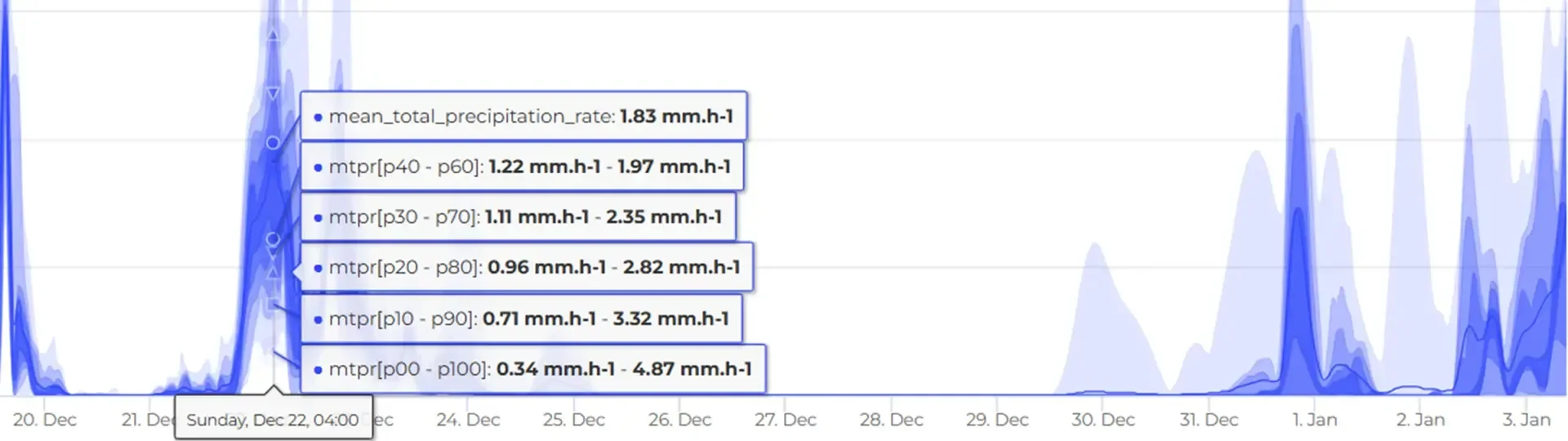
Frogcast is a cutting-edge global weather forecasting API that provides extremely precise and localized weather predictions by integrating over 20 advanced numerical weather prediction models with state-of-the-art artificial intelligence and diverse geospatial data from top-tier organizations such as ECMWF and NOAA, alongside earth observation data and ground-level measurements, to aid crucial decision-making in fields like agriculture, construction, logistics, retail, insurance, environment, transport, and health. Its RESTful API grants access to an impressive array of more than 26 meteorological variables, offering forecasts that extend up to 15 days into the future, along with probabilistic forecasts that include confidence intervals and quantiles for enhanced understanding, all while delivering high spatial resolution down to 1 km and detailed topographic information at 90 m for focused targeting of specific areas. The Frogcast platform is designed for effortless integration into current systems and applications via intuitive API endpoints utilizing standard web protocols and JSON data formats, which facilitates both real-time and historical weather data analysis for trend identification and decision support. Additionally, the flexibility of the API allows for customization based on user needs, enhancing the overall user experience and effectiveness of the weather data provided.
Description
MetGIS is a comprehensive weather data tool that combines advanced meteorological models with high-resolution terrain data to deliver ultra-accurate weather forecasts and information worldwide, with precision down to 30 meters and special strength in complex terrain such as alpine regions. MetGIS offers a suite of weather APIs including the Point API for detailed location-based forecasts, the Maps API for high-resolution weather layers integrated into map apps, the Hist API for precise historical weather data, long-range forecasts, and weather warnings, all easily integrated into websites, mobile apps, and business systems. It also provides interactive visualization through the MetGIS Pro+ weather dashboard, which displays fully zoomable forecast maps, 3D graphics, and detailed forecast tables accessible via web browser, plus PDF weather reports and snow and winter products for specialized use cases. MetGIS includes extensive documentation and support for developers, and its weather services are backed by scientific research and continuous verification to ensure high forecast quality. MetGIS products support a range of parameters such as temperature, precipitation, wind, cloud cover, and snow data, making the system suitable for professional applications across industries that rely on precise weather insights.
API Access
Has API
API Access
Has API


Pricing Details
€54 per 400 requests per month
Free Trial
Free Version
Pricing Details
No price information available.
Free Trial
Free Version
Deployment
Web-Based
On-Premises
iPhone App
iPad App
Android App
Windows
Mac
Linux
Chromebook
Deployment
Web-Based
On-Premises
iPhone App
iPad App
Android App
Windows
Mac
Linux
Chromebook
Customer Support
Business Hours
Live Rep (24/7)
Online Support
Customer Support
Business Hours
Live Rep (24/7)
Online Support
Types of Training
Training Docs
Webinars
Live Training (Online)
In Person
Types of Training
Training Docs
Webinars
Live Training (Online)
In Person
Vendor Details
Company Name
QUOS Group
Founded
2021
Country
France
Website
www.frogcast.com
Vendor Details
Company Name
MetGIS
Founded
2013
Country
Austria
Website
metgis.com
Product Features
Product Features
GIS
3D Imagery
Census Data Integration
Color Coding
Geocoding
Image Exporting
Image Management
Internet Mapping
Interoperability
Labeling
Map Creation
Map Sharing
Near-Matching
Reverse Geocoding
Spatial Analysis
