Average Ratings 10 Ratings
Average Ratings 0 Ratings
Similar Products
-
BidtracerBidtracer was developed by two highly engineers, combining expertise in mechanical, electrical, and computer engineering. This innovative tool serves as a specialized sales operations and channel partner solution specifically designed for the commercial construction sector. The tool simplifies the process of initiating sale opportunities, creating bid tracking plans, and specs, while also inviting subcontractors for assistance. This allows users to swiftly utilize the estimate tool to draft and send out proposals to customers. It assists sales professionals in automating their follow-up process with bids, enabling them to track and determine the winning contractor. This ultimately maximizes their chance of successful closing sale projects. Efficient project management is crucial to optimize time and maximize profits in construction projects. By automating various project management tasks, we can streamline operations and simplify all aspects of the project’s operational side.
-
SmartDrawSmartDraw makes professional drawings and diagrams accessible to everyone. Non-technical users can quickly create floor plans, while professionals get the precision and scale they require. With industry-leading floor planning tools and an intuitive interface for traditional diagramming like flowcharts and organizational charts, SmartDraw delivers enterprise-ready power without unnecessary complexity. Key features: - Large collection of symbols and templates - Ability to create custom shapes - Import PDFs, images, Google Maps, Visio files, Visio stencils - Draw to any scale - Enrich drawings with data - Generate manifest and bills of materials - Generate diagrams from data automatically like org charts, AWS, Azure, PI Boards, and more - Use natural language text prompts to generate diagrams with AI - Save files directly to OneDrive, SharePoint, or Google Drive, or other preferred provider - Integrations with the Microsoft and Google enterprise stack plus Confluence and Jira SmartDraw supports a wide range of industries and real-world use cases, helping teams plan, document, and communicate more effectively. Construction professionals use it to create scaled floor plans, site layouts, and electrical and plumbing drawings. Fire departments rely on it for fire pre-planning and incident documentation, while police departments use it for accident reconstruction and crime scene diagrams. IT teams build network diagrams and cloud architectures, HR leaders create organizational charts, and product managers map out processes and workflows. From physical layouts to business processes, SmartDraw provides a single platform that adapts to the needs of each role and industry.
-
BuildxactBuildxact is a construction management software that is easy to use for contractors, residential builders, and remodelers. It helps them manage their projects smoothly and efficiently. Transform your business with one system, from the first takeoff to the final invoice. Streamline estimation - Create takeoffs faster and get quotes 5x faster. Buildxact is cloud-based so you can get up and running in no time. Save time by ditching paper plans and spreadsheets! Buildxact digital takeoffs let you scale plans and measure with a few mouse clicks. Quickly measure and count materials knowing your numbers are correct. Easily move material counts into your estimate with online tools and pricing that are 5X faster than paper and pencil. Estimates that clearly lay out materials, labor and overhead for the client. Professional quotes that win more jobs. Find out today with a free trial!
-
InEightInEight delivers an integrated project controls platform designed specifically for capital construction. Its modular applications span every phase of the project lifecycle—from accurate estimating and planning to predictable execution and closeout. By unifying cost, schedule, contracts, documents, and field data in one system, InEight gives project teams real-time visibility and advanced analytics to drive confident decision-making. More than 850 organizations use InEight to manage over $1 trillion in projects across infrastructure, energy, mining, water, transportation, and industrial sectors. With InEight, construction leaders modernize operations, standardize best practices, and keep complex capital projects on time and on budget.
-
STACKSoftware that integrates takeoff and estimation for all trades and projects. You've come to right place if you want to save time, eliminate costly mistakes in estimating, and say goodbye to paper plans. STACK enables you to collaborate more efficiently and estimate more accurately, so that you can concentrate on what's important - your bottom line. Register for a free account now!
-
KonstructIQKonstructIQ is an innovative platform that integrates artificial intelligence to serve the needs of residential general contractors, remodeling companies, and home builders by streamlining both construction and financial management. This comprehensive tool covers the entire project lifecycle, encompassing fast and professional estimates, budgeting, invoicing, payment processing, change-order management, cost tracking, subcontractor coordination, and real-time reporting, all within a unified interface. Its estimating feature allows contractors to create precise bids swiftly, utilizing customizable cost codes and the ability to calculate markups or margins, as well as accommodating both cost-plus and fixed-price pricing models. Upon approval of an estimate, it transforms into the project budget, ensuring that every bill, invoice, or change order automatically reflects on the budget, enabling contractors to maintain precise job costing and oversight of profitability. Additionally, the platform facilitates payments to subcontractors or suppliers, supporting various methods such as ACH transactions, checks, debit and credit cards, virtual cards, or Zelle, while also enabling clients to pay invoices directly through a user-friendly portal, which accelerates cash flow significantly. This holistic approach not only simplifies administrative tasks but also enhances financial transparency for contractors, ultimately contributing to more efficient project completion.
-
StratosphereStratosphere, a cloud-based construction takeoff tool, gives estimators unprecedented freedom and flexibility to complete takeoffs wherever they are. Stratosphere is the ideal software for you if you are looking for a single tool that will save you time, give you access to your plans, projects, and doesn't force any changes in the way you estimate. Stratosphere can be used from any web browser. It can also be integrated with Microsoft Excel via our custom Excel Add-in. Stratosphere is free to download and use. We offer flexible monthly plans and annual plans with discounts for larger groups.
-
WERXWerx delivers powerful construction management tools at a price contractors love—starting at just $49/month. Built for small to midsized businesses, Werx simplifies your workflow with features like flexible estimating, AIA-Style billing, QuickBooks syncing, and labor tracking. Speed up payments with Stripe-powered online billing. Try Werx free for 30 days and see the difference! Tailored for contractors of all trades, Werx helps you save time, reduce stress, and boost profits. From managing schedules to tracking time in the field and creating polished invoices, Werx brings everything together in one easy-to-use platform. Affordable, reliable, and built to help your business grow—Werx is the smart choice for contractors.
-
Premier Construction SoftwarePremier Construction Software is an AI-powered cloud ERP built for growing general contractors who need tight control over job costs, WIP, and cash flow across multiple projects and entities. It unifies construction accounting, project management, and field operations so GCs can eliminate spreadsheets, speed up billing, and protect margins with real-time financial visibility. How we help GCs win more work and protect margin: • Construction cloud ERP built for general contractors, owners, and developers managing multi-project, multi-entity portfolios. • Advanced construction accounting with detailed job costing, real-time WIP reporting, and cash-flow forecasting to spot issues before they hit the P&L. • Integrated project and field management with RFIs, subcontracts, drawings, and change orders tied directly to the budget and schedule. • Automated billing, approvals, and payroll workflows (including subcontractor and pay app portals) to reduce manual entry and speed up collections. • Native AI and predictive intelligence that surface risks, recommend next actions, and provide executive-ready dashboards for owners and project leaders. • Unlimited entities, consolidated reporting, and role-based dashboards so finance and operations see the same numbers in real time. Trusted by GCs and Land Developers globally, Premier saves time, cuts risk, and helps you move forward with clarity. With Premier, you’re not just adopting software, you’re partnering with a trusted leader committed to your success.
-
ActCAD SoftwareACTCAD is suitable for professional drawings creation for Architects, Structural Engineers, Civil Engineres, Mechanical Drawings, Electrical drawings, interior design, tool design, machine designs etc.ActCAD is professional grade 2D Drafting and 3D Modeling CAD software which works in dwg and dxf file formats. Most affordable cad software.ActCAD is a native dwg/dxf cad software suitable for professional 2D drafting and 3D modeling projects. ActCAD is trusted by over 30000 users in over 103 countries for more than 10 years. The interface, commands, icons, dialogs, shortcuts etc. are very much similar to other popular cad software tools available in market. Flexible license types available even for single license. There is no learning for existing cad users while saving 80% of the costs.ActCAD offers free email technical support without any limitations. ActCAD can be fully customized and programs can be developed using our free API toolkit. It supports popular programming languages like , lisp dcl, .net, C++ etc. Apart from all regular commands, ActCAD offers many productive tools like pdf to cad converter, Block libraries, Image to Cad converter, handling point sets between Cad and Excel and many more.
Description
The future of CAD lies here
Mobile, powerful, and easy to use
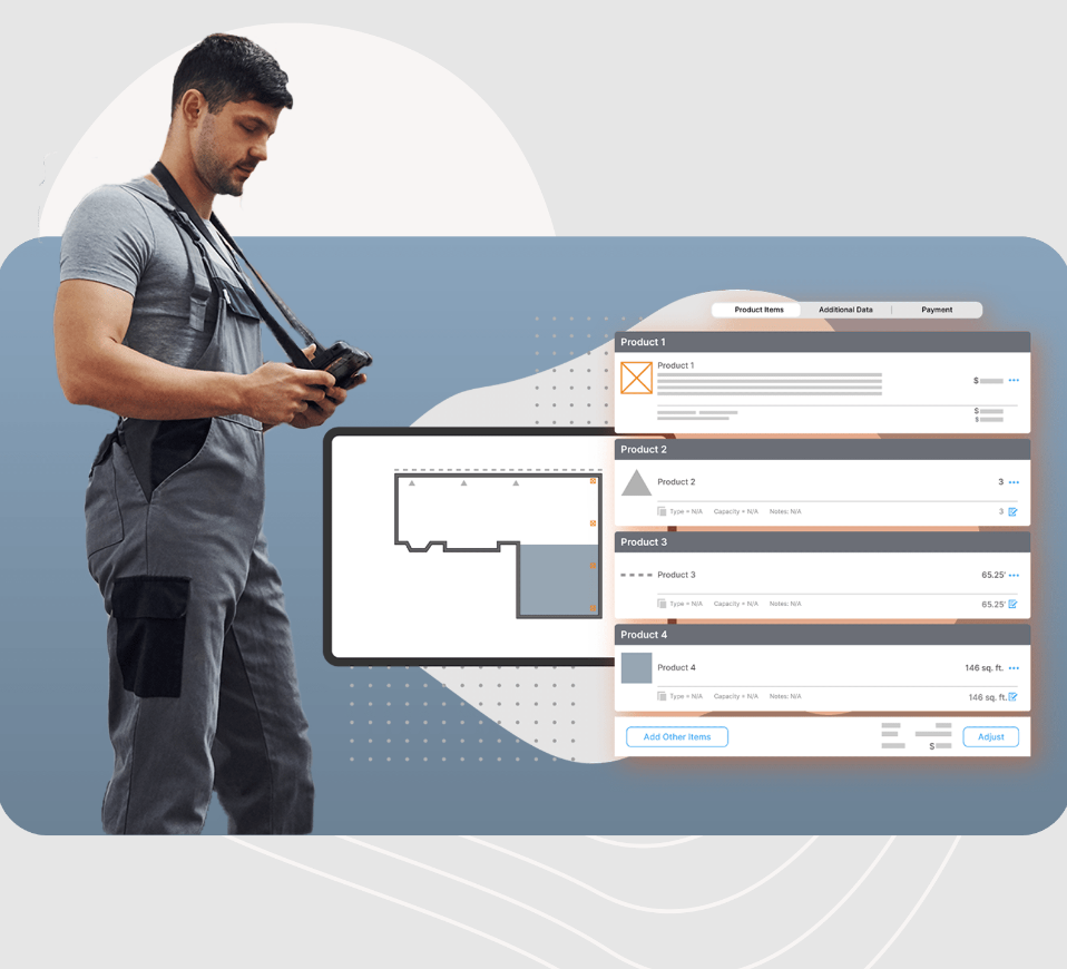
ArcSite is the most intuitive CAD drawing app on the market.
It's more than a tool to draw precise and accurate drawings on-the-go. It's a new skill set that will help you transform the way you do business.
Quick, easy, and accurate drawing:
ArcSite is a powerful CAD design tool that makes it easy for anyone to SKETCH FLOOR PLANS.
ArcSite is a favorite among contractors for home remodeling, audit, cabinetry and site surveys.
STAY ORGANIZED
Embedding on-site photos taken from the exact same perspective as they were taken in real life will enhance your drawings' visual information. You can easily add annotations, notes, or markups to any photo or drawing. All of your drawings can be saved in a cloud folder so that everyone has access.
PRESENT AND CLOSE
ArcSite lets YOUR DRAWINGS LITERALLY PRICKET THEMSELVES.
Description
Our basic service is completely gratuitous and allows you create custom maps, widgets and images. You can share your custom maps with your friends or publish them on your website/blog.
Scribble Maps Pro gives more control over your map data. Pro features advanced editing tools, formats and security options. Our API allows you to integrate Scribble Maps directly in your application. Our API is available to assist you in any way you need, including map authoring, annotation, and sophisticated interactivity.
API Access
Has API
API Access
Has API


Integrations
ArcGIS
QuickBooks Online
Salesforce
Stackreaction
WatchGuard WIPS
improveit! 360
Integrations
ArcGIS
QuickBooks Online
Salesforce
Stackreaction
WatchGuard WIPS
improveit! 360
Pricing Details
$15 per user per month
Free Trial
Free Version
Pricing Details
$168 per year per user
Free Trial
Free Version
Deployment
Web-Based
On-Premises
iPhone App
iPad App
Android App
Windows
Mac
Linux
Chromebook
Deployment
Web-Based
On-Premises
iPhone App
iPad App
Android App
Windows
Mac
Linux
Chromebook
Customer Support
Business Hours
Live Rep (24/7)
Online Support
Customer Support
Business Hours
Live Rep (24/7)
Online Support
Types of Training
Training Docs
Webinars
Live Training (Online)
In Person
Types of Training
Training Docs
Webinars
Live Training (Online)
In Person
Vendor Details
Company Name
ArcSite
Founded
2014
Country
United States
Website
www.arcsiteapp.com
Vendor Details
Company Name
52 Stairs Studio
Founded
2009
Country
Canada
Website
www.scribblemaps.com
Product Features
Architectural CAD
2D Drawing
3D Modeling
Architectural Symbol Library
Automatic Formatting
BIM Modeling
Comparison View
Design Templates
Drafting
Construction Bid Management
Bidder Management
Building Product Database
Cost Database
File Sharing
Proposal Management
Quotes / Estimates
RFP Management
Subcontractor Management
Takeoff
Version Control
Construction Estimating
Accounting Integration
Audit Trail
Bid Management
Billing & Invoicing
Building Product Database
Calculators
Change Orders
Contract Management
Cost Database
Customer Management
Customizable Templates
Electrical Estimating
HVAC Estimating
Historical Database
Job Costing
Plumbing Estimating
Price Data / Price Books
Project Management
Quote Management
Reporting/Analytics
Scheduling
Subcontractor Management
Takeoff
What-if Analysis
Floor Plan
2D Floor Plans
3D Floor Plans
Annotation
Diagram Templates
Document Management
Drafting
Drag & Drop
Lighting Control
Object Library
Rendering
Punch List
Collaboration
Commenting / Notes
Document Management
Drag & Drop
Drawings Integration
Include Photos In Reports
Issue Tracking
Quality Control Checklist
Task Management
Residential Construction Estimating
Bid Management
Billing & Invoicing
Building Product Database
Change Orders
Customer Management
Project Management
Quote Management
Scheduling
Takeoff
Takeoff
3D View
Assembly Takeoff
Cross Section Creation
Electronic Plans
Elevation Checking
Error Checking
Site Balancing
Slope Routines
Subcontractor Management
Product Features
GIS
3D Imagery
Census Data Integration
Color Coding
Geocoding
Image Exporting
Image Management
Internet Mapping
Interoperability
Labeling
Map Creation
Map Sharing
Near-Matching
Reverse Geocoding
Spatial Analysis
Route Planning
Capacity Planning
Drag & Drop Scheduling
Driver Management
Emergency Dispatch
GPS Tracking
Performance Metrics
Route Costing
Territory Management
