Please create an account to participate in the Slashdot moderation system


Forgot your password?
typodupeerror
×

Comment Magma ocean != 100% melt (Score 2) 48

A magma ocean is not a 100% liquid rock layer beneath the surface.

The observations made by this team are consistent with a 50 km-thick layer about 50 km below the surface (that is, within the mantle) with >=20 volume% melt fraction. This work is based on how Io affects Jupiter's magnetic field.

Other research teams have demonstrated, since the 1990s that Io should have a mantle with a >= 20 volume% melt fraction at some depth in the mantle--it was never clear where this magma ocean was located. This work is based on observations of the surface eruptions and models for how quickly silicate lavas cool.

The fact that these agree is significant.

A substantial portion of Io at 100 volume% melt would actually not work because pure liquid does not dissipate enough of the energy from the tidal forces to maintain 100 volume% melt. That is there's a feedback loop between Io's interior and the tidal flexing:

* Too much liquid in the interior and the energy dissipation will decrease significantly, allowing the liquid to cool enough to solidify significantly.
* Too little liquid and the interior would quickly dissipate enough tidal energy (in the form of friction) to significantly melt the interior.

So, Io's orbital resonances keep a small part of its mantle molten at between 20 volume% and 50-70 volume.

That there's now a depth associated with this magma ocean is actually quite significant. We can start better understanding the role volatiles play in Io's volcanism now that we know where the molten rock is coming from.

Comment Re:Okay, hold on a minute. (Score 2, Interesting) 184

Venus is basically the same size as the Earth.
Earth's mean radius is 6,371 km. Venus' mean radius is 6052 km.
The masses are also similar, as are their compositions.

A more likely control on whether plate tectonics may be initiated is the existence of liquid water at the surface and within the lithosphere of the planet in question. Water greatly reduces the yield strength of plates (by as much as 62% when going from low to moderate temperatures compared with a drop of only 39% for dry olivine). So, while plate tectonics seems to be necessary for life, water (necessary for life) may be necessary for plate tectonics. Venus is just at the range from the Sun where it could have lost all of its water too quickly for plate tectonics to initiate (especially if it lost the water long before the planet was mostly still molten).

Comment So? (Score 5, Insightful) 463

So, someone represented a company that has different ideas than you do...and that's a problem because?
Do /.ers really believe that their employer is their sole identity defining characteristic?
Are all of you who work for asshole-bosses also assholes?
It sure seems that that's what you're all saying when you go on these witch-hunts.

Comment Re:'habitable zone' .. (Score 1) 97

I'm not sure what you mean when you talk about 10% of a planetary surface and AUs.

Earth's surface area is 5.1x10^8 km^2. 10% of that is, obviously, 5.1x10^7 km^2. The land area of the US is about 9.8x10^6 km^2, so we're talking about 5-times the land area of the US. None of this has anything to do with distance from the star, just to do with the radius of the planet.

But, as you say, the point of 10% isn't that it's a special number; it's a starting point. Notice that this definition explicitly excludes any gaseous planets from the get-go. That's not necessarily fair, of course, but we've got to start somewhere, and rocky planets are a LOT simpler to understand w.r.t. possibilities of life.

Earth's average albedo isn't really all that controversial or problematic. For example, we can say that the poles probably had such and such an albedo at such and such a time (based on climate models based on core samples), the clouds are difficult for a specific times (decades or so), but again the climate will dictate some average cloud cover that is relatively accurate over long periods over the entire Earth.

Going into more detail would require an actual climate model (such as the Hadley model), which doesn't make much sense for extrasolar planets since we know next to nothing about atmospheres (especially their composition) on most extrasolar planets. Of course, we can speculate and use places like Titan, Mars, Venus, Earth, and Triton as jumping-off points for planets that are certain distances from their parent star.

Milankovitch cycles are certainly included in long-term habitability or continuous habitability zone research, but we're really limited by not knowing anything about the obliquity/precession cycles of extra-solar planets, which are quite dependent on specific circumstances of those planets.

The T-tauri phase of the pre-main sequence stars would strip almost any magnetic field-protected atmosphere from most planets, so we're fairly confident that any planets found orbiting such stars are uninhabitable. In fact, there are a lot of stars that can be ruled out (of having any sort of habitable zone) just by looking at them.

Habitability zones are for "well-behaved" stars with well-behaved planets. Some researchers are looking at double or triple star systems, so we'll have a better understanding of the possibility of life in such systems as time goes on.

Comment Re:'habitable zone' .. (Score 1) 97

Yes, the moon is within the habitable zone, but it's not habitable. If we discover a rocky planet in the habitable zone of another star, the first thing we'll be looking for is an atmosphere (which is quite a bit more difficult than finding the planet, but techniques are being developed and tested). If we discover evidence for an atmosphere, the habitability of that planet jumps into a realm that is much more interesting. Then we start looking for evidence of certain gases in the atmosphere (water vapor, CO2, Nitrogen, etc.).

Comment Re:'habitable zone' .. (Score 1) 97

Well, first, let's go into some history.

A habitable zone around a main sequence star was originally (1959) defined as a (virtual) ring around that star in which at least 10% of the surface of a planet, with an Earth-like atmosphere, in that zone had a mean temperature of between 0 and 30 C with extremes not exceeding -10 and 40 C. This is appropriate for humans to survive.

The zone was quickly expanded to mean wherever liquid water was stable. The term "biostable" was employed to mean where liquid water was stable and the term "habitable" was restricted to mean a place suitable for humans. Soon, though, "habitable" was expanded to replace "biostable" and to include anywhere that liquid water is stable.

All (peer-reviewed) models since the original definition have used one type of atmosphere or another, usually an atmosphere chemically similar to Earth's. Most have also considered planetary albedo (surface brightness), solar evolution (as a star moves along the main sequence, the habitable zone changes or disappears, depending on the details), etc.

Several models have pessimistic estimates to the width and/or lifetime of a habitable zone, most often because an atmosphere like the Earth's is only metastable and it could collapse with only a few % change in solar energy input (distance from or luminosity of the sun, for example can greatly affect the stability of an atmosphere). Other models have included climate stabilization by linking CO2 and surface processes such as the creation/weathering of certain types of rock that remove/add CO2 from/to the atmosphere. There are a lot of these kinds of details that are included in most models of the habitable zone. A lot of the work is in determining which details are more important than others.

For my graduate work, we had to define the habitable zone around the sun, at the beginning of the solar system (4.556 Ga), and now. To do so, we had to start from the proplyd, condense all of the elements at the right distances from the sun, build the planets (we were allowed to assume that they formed in their current positions unless we wanted to make our work more difficult), allow atmospheres to condense or form, depending on where the planets were, etc., and finally determine which planets were possibly in the habitable zone as the sun evolved (Venus, Earth, and Mars, depending on the details and assumptions), and then determine whether the planets that are here now are in the habitable zone, and why or why not.

We, of course, used some pretty simple 1-D models for atmosphere, or used published models and argued why they were valid. We used simple models for planetary albedo, didn't evolve the albedo unless the atmosphere collapsed or changed dramatically in some other way (ignored Earth-like clouds, for example), etc. We used simple estimates for the concentrations of radioactive elements that could contribute to the surface temperature, used a simple model for luminosity evolution, etc., etc., etc.

For these kinds of simple models, the inner edge of the habitable zone is defined by when water will be lost from the atmosphere (through photolysis of the water vapor and escape of the hydrogen) and the outer edge is defined by when CO2 condenses and causes runaway glaciation.

Technically, the Moon is within the habitable zone, but it's obviously not habitable. Neither are Venus or Mars. This is because they don't have the right atmosphere, and may never have had the right conditions.

Comment Re:While not in an area of space considered habita (Score 1) 97

I make no guarantees to that assertion's applicability other than in the context in which it was originally intended.

The "holy grail" (so to speak) right now is finding evidence for ANY life outside of our planet. Doing so would change our relationship with the universe in many ways (even though most relevant scientists are much less agnostic than they should be when it comes to the question of whether life exists elsewhere in the universe). Once we find life in one place not on Earth, we'll be much more open to the idea of looking all over for it and for other forms of life than what we're familiar with. So, until that first goal is achieved, we'll look where we think we're most likely to find life.

Comment Re:While not in an area of space considered habita (Score 1) 97

Oh, you're not "very wrong."

We can only recognize life as we already understand it. A common medical exam question is to define life. A common graduate school exam question is to define life. How do we do that? Based on what we know.

We know that life (as-we-know-it) requires a few conditions, so we look for planets that could support those conditions.

Nobody thinks that's the only place to find life, but it's probably the easiest place to find life that we would understand...

Comment Re:Is there a doctor (of astronomy) in the house? (Score 5, Informative) 97

The Roche limit is defined as:

d = R ( 2 rhoM/rhom) ^ (1/3).

d is the orbital distance.
R is the primary (star in this case) radius.
rhoM is the primary's density.
rhom is the satellite's density.

If rhom > 2 rhoM, d is inside the radius of the primary.

The star in question is similar to ours, so I'll use our sun's density: 1.4 g/cm^3
The planet's density is 8.8 g/cm^3.

Therefore, the roche limit is within the star's radius and the planet will not be ripped apart.

This presumes a nearly circular orbit, which is good enough for this case.

Comment Re:Plane (Score 5, Informative) 97

Yes. Mostly. For this (transit photometry) method.

There are several methods of finding an extrasolar planet.

Briefly:
1) Pulsar variations: If a planet orbits a pulsar, the pulsar's timing will vary in a manner that can be detected by us, and we can use 3-D trig to figure out relevant parameters such as mass and radial distance.
2) Doppler shift of a star's emission lines: If a planet orbits a solar-type star, we can use the star's doppler shift of certain spectra to determine the various parameters of the body (or bodies) orbiting the star.
3) Gravitational microlensing: If two stars align just right to create a microlensing effect, the star further from us will show up as several images or as an Einstein ring, and its brightness will be amplified. If there's a planet orbiting the star that's closer to us, those mirror images or the ring will change with time, and they will be a bit brighter than without the planet.
4) Astrometry (measurements of the variation of a star's position relative to the "plane of the sky"): If there's a massive planet with an eccentric orbit, the star will orbit a barycenter that's outside of its mass, causing the star to move relative to the background.
5) Direct imaging: with certain techniques for processing stellar imagery, we can detect whether or not there's a planet reflecting some of that star's light to us.
6) Transit photometry: observing the star's brightness decrease as the planet eclipses the star. This works best for planets with a perfect orbital alignment with us, but we can still detect and work out minimum values for the relevant parameters.
7) Radio flux: Certain jovian-type planets can emit radio fluxes that differ significantly from most stars. These fluxes can be difficult, though not impossible, to detect from the interstellar noise.

There are more methods...

Comment Re:Wow (Score 1) 60

1) These images are not photoshopped (at least not the ones on uahirise.org). If you knew anything about remote sensing, CCD sensors, image processing, or science, you'd know that.

        http://www.uahirise.org/pdf/color-products.pdf [uahirise.org]

Have you actually read that PDF?

(My emphasis)

"PSP_005000_1000_RGB.NOMAP.JP2 3-color image consisting of RED, BG, and synthetic blue images. The BG image has been warped to line up with the RED.NOMAP image. The BG (blue-green) bandpass primarily accepts green light. The synthetic blue image digital numbers (DNs) consist of the BG image DN multiplied by 2 minus 30% of the RED image DN for each pixel. This is not unique data, but provides a more
appealing way
to display the color variations present in just two bandpasses, RED and BG."

"For the Extras products, each color band is individually stretched to maximize contrast, so the colors are enhanced differently for each image based on the color and brightness of each scene. Scenes with dark shadows and bright sunlit slopes or with both bright and dark materials are stretched less, so the colors are less enhanced than is the case over bland scenes."

Whether one uses Photoshop or other software to enhance images to become more pleasing or effectful, it's generally called photoshopping.

Mars may look rather dull compared to Earth, and there's not much light there. But I'd much rather see things as they are, and the IR imagery displayed separately (preferably as black/white, as is traditional as it doesn't give any false impressions that it's visible light). That would be much more impressing than artificial colour "enhancements" and contrast stretching individual colour bands to make the images appear more colourful.

In many ways, exaggerating space images that are already impressive because they are from space to make more of an impact on the public isn't much different from photoshopping people to make their eyes bluer, lips redder, teeth whiter, and wrinkles less visible.

You CANNOT "see things as they are" with the HiRISE images.

1) Does your monitor display Infrared?
2) Does your monitor display "red" with the same bandpass that the HiRISE detectors are sensitive to?
3) Does your monitor display the bluegreen that HiRISE is sensitive to?
4) Are your eyes sensitive, in the same way as the HiRISE detectors, to the same bandpasses as the HiRISE detectors?

No.

5) It simply isn't "traditional" to show IR or other non-visible wavelength data as a separate grayscale image. Take a look at Hubble images.
6) The difference between photoshopping and processing these images is: a) there's documentation on exactly how it's done, and why, b) the "original--whatever that means" images are available to anyone who actually has an interest in the imagery rather than complaining about scientists.
7) Mars doesn't look dull compared with Earth. The bandpasses were chosen for science. The public images are just that, to excite the public. If you want to do science, then go to the original source. If you want to look at pretty pictures, then look at the pretty pictures.

What, precisely, would you like to see?

Would you like to see the raw numbers that come out of the detectors? Those won't do you much good since you clearly don't know anything about Mars science or remote sensing. Some amount of the "signal" is actually generated by the instrument. In addition, some amount of the "signal" is due to heat generated by the spacecraft, other instruments, etc. If you would like to see the raw data, go here:

http://hirise-pds.lpl.arizona.edu/PDS/EDR/PSP/ORB_001500_001599/PSP_001552_1410/

Those raw data are reduced (calibrated) as soon as they hit the ground. Would you like to see those values? Would you like to see a representation of those values on your screen, in the form of an image?

Realize that the images you can view are different because your screen is an 8-bit display and the data acquired through HiRISE are 14-bit compressed to 8-bit, downlinked to Earth, uncompressed to 32-bit, processed in floating point, and recompressed to 10- or 8-bits, depending on the output format. Your screen can't display what was actually detected (raw) by the HiRISE instrument.

Instead of assuming that everyone in the world but yourself is dishonest, try doing a little---very, very, very little---digging and learning instead of trolling.

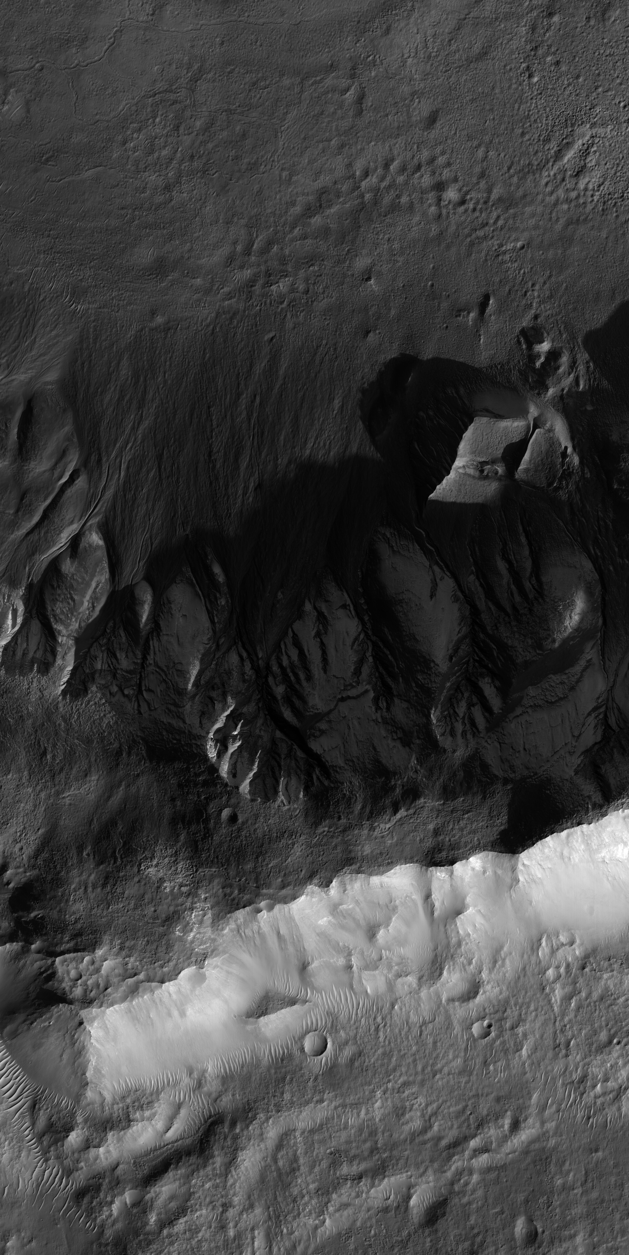
Here's the main page for the frost-covered gullies shown in the article:
http://www.uahirise.org/PSP_001552_1410

The mosaic of the red bandpass CCDs is here (not map projected, because I'm sure you'd find something to complain about there, too):
http://hirise-pds.lpl.arizona.edu/PDS/EXTRAS/RDR/PSP/ORB_001500_001599/PSP_001552_1410/PSP_001552_1410_RED.NOMAP.browse.jpg

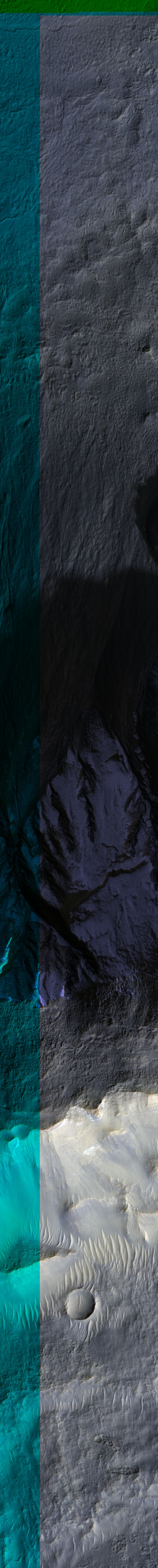
The mosaic of the blue-green, IR, and red bandpass CCDs is here:
http://hirise-pds.lpl.arizona.edu/PDS/EXTRAS/RDR/PSP/ORB_001500_001599/PSP_001552_1410/PSP_001552_1410_IRB.NOMAP.browse.jpg

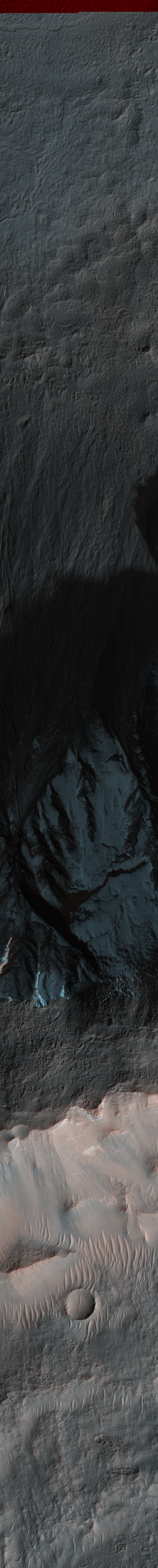
The color mosaic, with the stretching to enhance the color differences, is here:
http://hirise-pds.lpl.arizona.edu/PDS/EXTRAS/RDR/PSP/ORB_001500_001599/PSP_001552_1410/PSP_001552_1410_RGB.NOMAP.browse.jpg

Realize that NONE of the images here show Mars as it would look to your eyes. None.

Also, all of those data are directly available from the front page for the image, including the raw data. So, clearly you didn't bother trying to find what you want to see, you just started bitching because you have some bone to pick with scientists.

Slashdot Top Deals

The Tao is like a glob pattern: used but never used up. It is like the extern void: filled with infinite possibilities.

Working...