
Journal beej's Journal: GPS
Ostensibly, I was purchasing it so I could find scuba dive sites while diving from my sea kayak. I just haven't bought the kayak yet.
If you get a GPS, I wholeheartedly recommend one with a map, and one with a data transfer cable. Garmin is nice enough to have published their data communications protocol which means there's a slew of free software out there supporting their products, on Linux even!
Geocaching, in case you don't know, is basically the global equivalent of an easter egg hunt. You get the coordinates of the cache from the Geocaching.com or Navicache.com website, and head out there to find it. Usually your GPS will get you within 15-20 feet of your goal, and then the rest is a bit of hunting around.
Which to choose, Navicache or Geocaching? Geocaching.com has something like 95% of the geocaches in the world listed on it. People like it more because it has more share. It's also a bit more of a business than Navicache is. Navicache is a lot more free with their data (it's a serious business asset, after all) which you can download in their own XML format through a perl CGI GET script.
Being a free information sort of guy, I really like Navicache...but most of the caches I find are from Geocaching--there are just more of them!
Geocaching will let you sort of download raw data, too, but not in bulk. They use a different XML format.
There is a third XML format that is trying to become the standard: GPX. It's pretty complete for basic data, and other sites could extend it as they so chose. As far as I know, neither Geocaching nor Navicache support this format.
Once you have your data in a standard format (try using gpsbabel to convert it) you can pass it on to a variety of mapping programs that will plot waypoints and tracks on topo maps, aerial photographs, and so on.
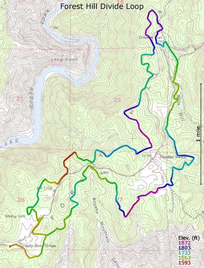
One of these is available online through a CGI interface: GPS Visualizer. It returns the results in SVG format which requires an Adobe plugin, but they seem to have plugins for Linux and OSX, as well as Windows. Very useful if you want to, say, plot a trail map of your hike.
In short, I have a grand time with this thing. The Legend is a high-mid-range GPS, and I got it on sale at Amazon for only $150. If you don't have one already, perhaps it's time to consider getting outdoors a little more often.

GPS More Login
GPS
Slashdot Top Deals